


SkyDemon
Beschrijving van SkyDemon
SkyDemon is één van Europa's meest populaire oplossingen voor VFR vlucht planning en in-flight navigatie.
Gebruik deze app toegang tot uw SkyDemon abonnement op je Android toestel, het ontsluiten van SkyDemon krachtige functies terwijl ze onderweg zijn.
EIGENSCHAPPEN FLIGHT PLANNING
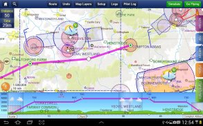
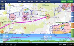
- SkyDemon vector grafieken zijn de duidelijkste luchtvaartkaarten u ooit zult gebruiken, met dynamische luchtruim knippen en de keuze van kaartlagen
- Route planning is zo simpel als het aanraken van opeenvolgende waypoints en te slepen om wijzigingen aan te brengen
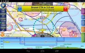
- Virtual Radar laat zien hoe uw route betrekking heeft op het luchtruim, terrein, obstakels en andere functies
- Pilot Log faciliteit berekent rubrieken en groundspeeds van de werkelijke wind data, en toont bruikbare frequenties
- Platen en andere documenten voor relevante vliegvelden worden automatisch weergegeven als u van plan bent, en velen zijn beschikbaar georeferenced voor gebruik tijdens de vlucht
- Intuïtieve pan, knijpen en draaien ondersteuning zonder verlies van kaart duidelijkheid en leesbaarheid van de tekst
- Dien een VFR vluchtplan voor uw route rechtstreeks naar luchtverkeersleiders
- Automatische TAF, METAR en SIGMET briefing als u van plan bent een route, met grafische decodering
- Neerslag gegevens kunnen worden overlay op de kaart, met animatie, met de trend van de regenval in de tijd
- Integratie van GAFOR route prognoses voor Zwitserland, Oostenrijk, Slovenië en Kroatië
- Zowel de smalle weg en het gebied NOTAM briefings beschikbaar, bijgewerkt als u van plan bent
- Geavanceerde NOTAM grafische interpretatie en weergave op de kaart,
- Eenvoudig print uw PLOG en de uitvoer van diverse briefings
- Waarschuwingen voor het luchtruim en andere potentiële gevaren voor uw vlucht, in real time bijgewerkt
- Airfield Admin laat zien wat nuttige contacten en andere informatie voor vliegvelden te zien in onze charts
- Forecast winden omhoog worden automatisch opgehaald voor de vlucht tijd en weergegeven op de kaart
- Maak een geavanceerde profiel vliegprestaties voor elk vliegtuig dat u gebruikt
- ATS Routes mode biedt een alternatief grafiek presentatie voor de vlucht langs de luchtwegen
- Nauwkeurige brandstof, gewicht en balans berekeningen inclusief vlucht kostprijsberekeningen
- Creëer een onbeperkt aantal door de gebruiker gedefinieerde waypoints
- Analyseer je track logs voor het nageslacht
- U kunt kiezen uit zes verschillende vector grafiek stijlen
- Uitgebreide Europese chart dekking als standaard
GPS NAVIGATIE EIGENSCHAPPEN
- Intelligente waarschuwingen voor het naderen van het luchtruim, NOTAM, obstakels, terrein en andere gevaren
- Virtual Radar toont een zij-on projectie van alle functies te benaderen en hoe uw traject op hen betrekking heeft
- Vector kaart volgt automatisch het vliegtuig in Noord-up, track omhoog of cursus up oriëntatie
- Duidelijke en beknopte instrumenten laten u statistieken vlucht en helpen houden u op het goede spoor
- Een HSI / ILS instrument helpt je te houden aan de geplande route en de line-up vroeg voor aanpak
- Live-Pilot Logboek toont vooruitgang door middel van uw route, ETA, ATA's en nuttige frequenties op basis van uw huidige positie
- TerrainSafe dynamisch kleuren bergachtige terrein rond om snel veiliger gebieden aan te wijzen
- Direct To maakt een eenvoudige re-routing in een haast door het plukken uit een selectie van de nabijgelegen vliegvelden
- Aanpak informatie toont baan diagrammen, TAF, METAR, NOTAM en andere vliegveld informatie nuttig zijn voor het maken van een benadering
- Live updates van TAF en METAR tijdens de vlucht, met bijbehorende waarschuwingen *
- Uitgebreide baan hartlijnen verschijnen automatisch op de kaart als je de buurt van uw bestemming vliegveld
- Permanente weergave van de positie ten opzichte van de dichtstbijzijnde bekende waypoint, voor de positie van de rapportage
- Eenvoudige wisseling van de geplande route, terwijl de vlucht door het aanraken en slepen
* Internetverbinding vereist voor live weer-update tijdens de vlucht
SkyDemon - versie 4.0.2
(28-01-2025)SkyDemon - APK-informatie
APK-versie: 4.0.2Pakket: aero.skydemon.skydemonandroidNieuwste versie van SkyDemon
Andere versies


Apps in dezelfde categorie

Mogelijk vind je dit ook leuk...


